Imperial Solar West & South
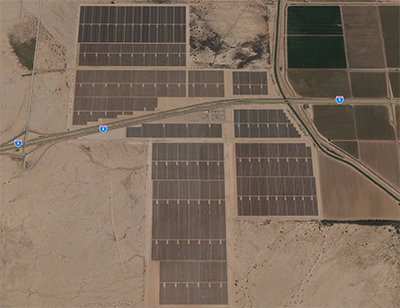
BRG prepared two joint EIR/EAs for the Imperial Solar Energy Center West project and the Imperial Solar South Project. The County of Imperial was the CEQA Lead Agency and BLM was the NEPA Lead Agency. The projects, now in operation, consisted of a 250 MW solar energy facility on 1,130 acres of land in the unincorporated Seeley area of Imperial County in the west, and construction, operations/maintenance and decommissioning of a 200 MW solar energy facility on 950 acres of private undeveloped and agricultural lands in in the unincorporated Mt. Signal area of Imperial County to the south. They are some of the most prominent features upon entering Imperial Valley from the west. The solar generating facilities included two optional technologies: “concentrating photovoltaic” (CPV) solar and “photovoltaic” (PV) solar. The primary difference between the two being the height and orientation of the solar panels. The solar generating facilities interconnected to the utility grid at the Imperial Valley Substation via a five-mile 230kV transmission line within BLM’s Utility Corridor “N”. Key resource impacts included conversion of agricultural lands; biological impacts from habitat loss; and visual impacts from solar/transmission facilities.
The majority of the project area consisted of disturbed agricultural lands that had been fallow for over 10 years. For this reason, the EIR/EA included a Land Evaluation and Site Assessment to determine potential impacts from the temporary conversion of agricultural lands to non-agricultural uses. The EIR/EA also identified several options for mitigating significant agricultural impacts to below a level of significance.
In addition to disturbed/ agricultural lands, multiple vegetation communities were identified within the project area, including desert washes that flowed through the transmission corridor. Biological surveys included rare plant surveys; protocol nesting season surveys for burrowing owl, southwestern willow flycatcher, and wintering mountain plover; and, a preliminary delineation for jurisdictional resources. Through mitigation measures incorporated into the project design, along with Section 7 consultations with the US Fish and Wildlife Service, impacts to biological resources were avoided, or reduced to below a level of significance.
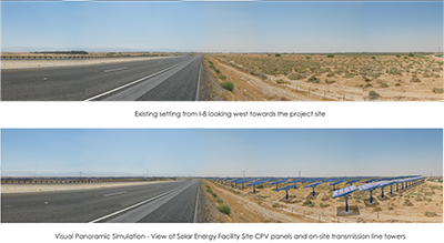
Using the BLM’s Visual Resource Management System, BRG prepared visual simulations of the proposed solar generating facilities (both CPV and PV technologies) and the 230 kV transmission line. Key Observation Points were used to identify viewsheds, visual resources, and to prepare the simulations. The visibility analysis was used to support the EIR/EA’s finding that while the project would be visible from vehicles traveling along I-8, it would not substantially degrade the existing visual character or quality of the area.